
This is a detailed guide featuring everything you need to know about the new Bulak-Ashuu Lakes Trek from Jyrgalan Village in Kyrgyzstan.
Jyrgalan was once a prosperous coal-mining town during Soviet times, home to approximately 5000 people.
When the Soviet Union collapsed there was a reduced demand for coal and the local economy crashed, leading many to abandon their homes and leave the town.
While a former Soviet coal mining town may not sound like an ideal trekking base, don’t let this fool you.
The valleys around Jyrgalan are very much a hidden gem, offering some of the most scenic trekking in all of Central Asia.
Best of all, this trekking is accessible right out of your guesthouse door.
The work of Emil Ibakov has transformed this semi-abandoned town into an outdoor sports base.
This is a place you can feel good about visiting, knowing you are supporting a local community that has come through hard times in the not so distant past.
While tourism in Jyrgalan is slowly growing, it still has all the charm and friendliness of a sleepy village. There is now a small shop selling essentials, but no cafe, restaurant, or ATM, and horses still seem to outnumber people.
Jarryd and Alesha have visited this area numerous times helping to promote tourism in the town, and marking some hiking trails.
Here’s a list of their current trekking guides for Jyrgalan:
They have made no secret that Jyrgalan is their favourite place in Kyrgyzstan, and many of the guests on the NOMADasaurus Kyrgyzstan photography and adventure tours agreed with this opinion.
Emil and the team at Destination Jyrgalan are continuing to develop new trekking routes and activities in the area.
The Bulak Ashuu Lakes Trekking Guide
From the new trekking routes developed for the 2019 trekking season, the Bulak-Ashuu Lakes trek was the clear favourite with both guests and guides.
So far only around 30 people have visited the lakes, so the trek is ideal for anyone looking to get way off the beaten path and discover a little-visited area.
Even during peak trekking season, you will most likely have the lakes all to yourself.
How Difficult is the Bulak Ashuu Lakes Trek?
The trek is not easy, but you don’t need to be a super athlete either. The guides in Jyrgalan have found that for someone with average fitness a 3-day itinerary provides a nicely paced trek with plenty of time to stop for photos, rests, and snacks. A total distance of 44km over 3 days may not sound like a lot, but there is a total of nearly 2km total elevation gain and descent, plus a significant amount of the trek is spent above 3000m altitude.
How Do I Get to Jyrgalan?
Marshrutka 331 leaves from the Ak-Tilek Bazaar in Karakol at: 08:30, 11:30, and 17:30. The journey to Jyrgalan takes around 1.5-2 hours.
The bus is usually full, so arrive around 30mins early if you want to be assured a seat, otherwise you may have to stand.
The cost is 90-150som depending on how much luggage you have.
Marshrutka 331 leaves from Jyrgalan to Karakol at: 07:30, 11:30, and 16:30.
A taxi is around $20-30 each way depending on your negotiating skills.
READ MORE: Check out our ultimate guide to travelling in Kyrgyzstan!
Accommodation in Jyrgalan
There is a range of accommodation in Jyrgalan, which can be seen on the Booking.com website.
There is no café or restaurant in the village, however your accommodation will be able to provide you with hot meals and lunchboxes.
Be aware, there is no ATM in Jyrgalan. It is best to bring cash with you (Kyrgyz Som, Euros, or USD). Destination Jyrgalan can accept card payments for larger transactions.
How to Organise the Bulak-Ashuu Lakes Trek
If you know what date you want to begin the trek the best way to organize the trek is by contacting Destination Jyrgalan in advance via email (destination.jyrgalan@gmail.com).
This gives plenty of time for them to prepare a menu suitable for any dietary requirements, source guides and horses, and reserve camping equipment.
It is usually possible to arrange the trek once in Jyrgalan. However, this is not always the case, sometimes all the guides and/or horses may be booked out for other tours.
Independent vs Guided Trekking
The trek can be done independently without a guide. However, the trail is not marked and in some places you will be walking on animal tracks making your own route, rather than on an “official trail”.
Finding the route without a map and/or GPS device would be extremely difficult.
If you plan to do the hike independently we advise buying all food in Bishkek or Karakol, as there is a limited selection available in Jyrgalan.
Destination Jyrgalan can organize a full package tour including; guide, porter, horse to carry luggage, all camping equipment, and all food.
For those looking for someone else to take care of all the details this is a good solution, you simply can turn up the morning of your trek knowing everything is taken care of.
For people that don’t need a full package tour, but would like some assistance Destination Jyrgalan can provide any combination of the individual things included in the full package tour. This includes renting camping equipment.
How Much Does it Cost
For independent trekkers with their own camping equipment and food there are no further costs (e.g. permits or entrance fees).
A full package tour for two people currently costs USD$462 ($231 per person).
This includes everything you need (guide, packhorse to carry luggage, porter to look after horse and set up/take down tents, all food cooked for you, and all camping equipment).
If you don’t want the entire package and just need certain elements it is best to contact Destination Jyrgalan who can put together a custom package for you with the most up to date costs.
While it is possible to carry all your own equipment, a pack horse is usually suggested for maximizing comfort as it can carry all the heavy equipment leaving you free to carry just a small day bag.
Taking a horse also has the benefit of being able to carry you across the river crossings.
Don’t worry if you don’t have experience with horses, a porter always comes with the horse to look after it.
Trekking and camping equipment can be rented in Jyrgalan. Current costs are approximately:
- Trekking poles: $2 per day
- Sleeping bag: $2.50 per day
- Sleeping mat: $1 per day
- 2 person tent: $3.50 per day
- Camping stove: $2 per day
- Gas canister: $3.50 for a small canister, $7 for a big canister
What to Pack
There are a few essential items you’ll need to comfortably go trekking in Kyrgyzstan.
If you’re coming from Australia or New Zealand, we recommend picking up your gear from your local Kathmandu store.
- Comfortable backpack that can fit everything you need to carry. (If you have a packhorse a day pack is sufficient).
- Suitable footwear. Traditionally, this would be a good pair of hiking boots. However, some people have also completed the trek in trail running shoes. Whichever your personal choice of boots or trail running shoes, waterproof and lightweight models are recommended.
- Two t-shirts – one for during the day and one at night
- One light down jacket that packs down, or a lightweight fleece
- One waterproof/windproof shell jacket
- Thermal pants
- A “buff” bandana
- Some thin gloves just for cold mornings/evenings
- Three pairs of socks. One for trekking, one for wearing at night, and a spare pair in case the trekking socks get wet
- Crocs/sandals for fording rivers and the boggy area around them. Also can be worn around camp
- Trekking poles. Optional, but can help with balance during fording rivers.
- A water bottle (at least 1L)
- Sunscreen and sunglasses
- Headlamp or torch
- If you have electronics you will need to charge (e.g. camera and/or phone) a battery pack is essential
- Full camping gear – tent, sleeping bag, sleeping mat
- Food and cooking equipment (gas canister, camping stove, pot, cutlery etc.)
When to Go
Trekking season in Jyrgalan is from June to September. However, it is not unusual to have some snow still on the passes during early June, and at least part of the lakes may be frozen. July and August provide the most consistent good weather. By mid-September snow storms and very low temperatures at night are not uncommon.
Things to Know Before You Go
There are a few things to know to ensure you have a safe and enjoyable experience of the Bulak-Ashuu Lakes Trek:
- There are many good sources of clean water along the trail. Although, a filter or some kind of water purification system is advised to reduce the risk of sickness due to the presence of animals along the entire route.
- The weather in the mountains can be unpredictable, even in summer. It is recommended that anyone attempting this trek has clothing for all weather conditions.
- Bring any medication you require and some basic first aid equipment (plasters, bandages, antiseptic cream).
- Make sure your insurance covers trekking up to altitudes of 3521m (the highest point of the trek).
- The campsites are above the treeline, so don’t expect to find any wood to make campfires. If you need to cook food or boil water you should take a gas canister and camping stove.
Bulak-Ashuu Lakes Trekking Itinerary
To help you make the most of your time trekking to Bulak-Ashuu Lakes in Jyrgalan, here is my hiking guide and itinerary.
Day 1 – 16km – 6 hours
- Min Elevation: 2258m
- Max Elevation: 3100m
- Total Gain: +901m
The trek begins straight from your guesthouse door in Jyrgalan. Crossing a bridge over the Jyrgalan river at the South end of the village, and ascending a steep dirt track up to a plateau.
Here you will be treated to a nice Panorama of the village, with a backdrop of Char Jon Peak and Kok-Bel pass.
You will then join a rough jeep road taking you further South up the Jyrgalan Valley.
This road is rarely used, other than to transport the yurts to and from the Jailoos (high pasture areas) at the beginning and end of summer.
Occasionally a milk truck will also use this road to go and buy horse milk from the yurts.
To the right of the jeep road you will see Tulpar Tash (Horse Rock). This huge rock is featured in the famous Kyrgyz epic Manas, famously recited by mouth, rather than written down.
Manas reciters (Manasci) are highly respected in Kyrgyz society and often perform at festivals and special occasions.
In the epic, Manas is said to have united the Kyrgyz tribes in the local area to fight against the invading Chinese army.
As the battle began Manas leapt – on horseback – off the rock towards the Chinese soldiers, scaring them away. Today you can still see the footprints of the horse on the rock.
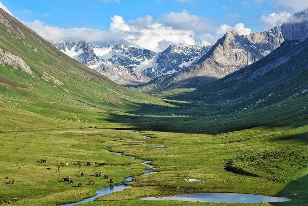
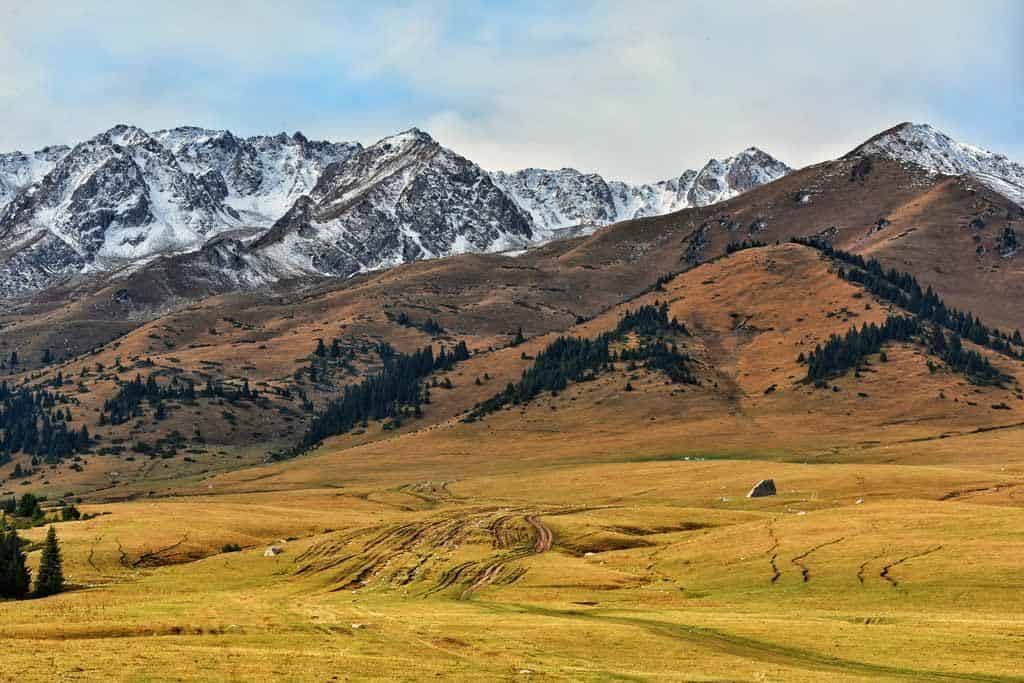
Continuing along the trail you will enjoy views of the incredibly green and vibrant Jyrgalan Valley, with snow-capped peaks in the distance.
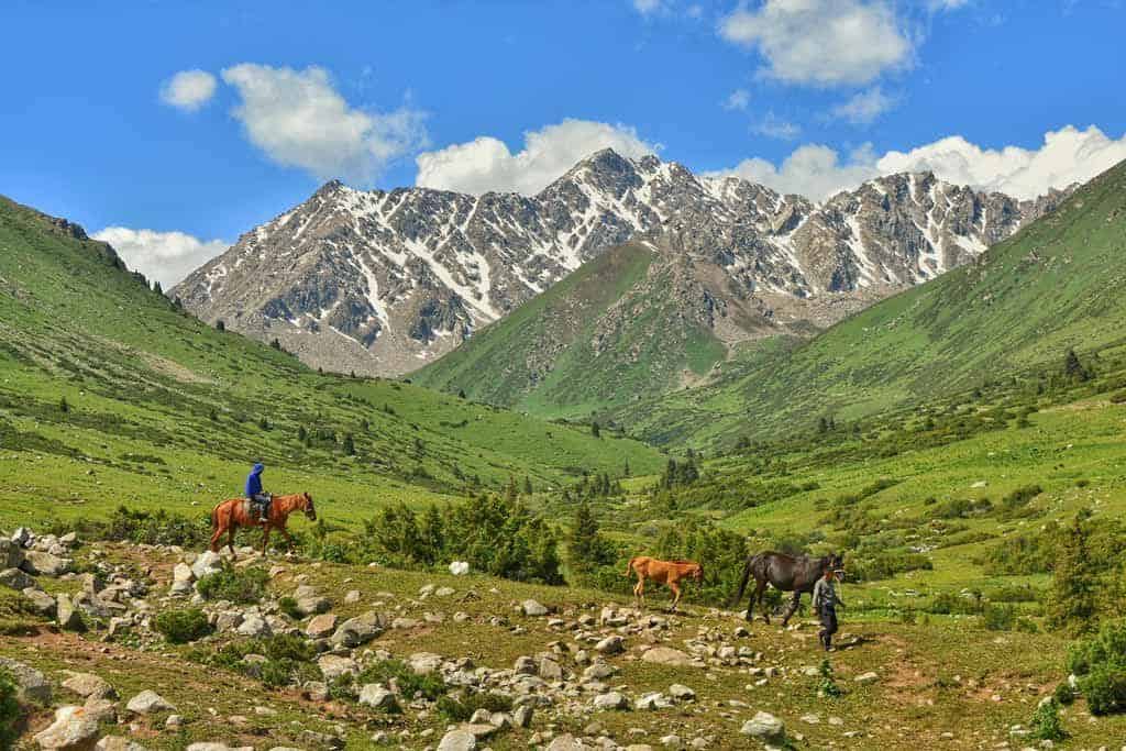
Along the way you will pass a few isolated yurts, and see shepherds moving their animals.
If you get close to the sheep look at their “fat tails”. This tail fat is considered a culinary delicacy, and often at animal markets you can see potential buyers inspecting the tails looking for the fattest one.
Around 6km from Jyrgalan there is a fork in the valley. Here you turn West before the bridge, leaving Jyrgalan Valley and entering Terim-Tor Valley.
After a couple of minutes walking you will reach a nice spot to stop for a lunch break, with views overlooking a small jailoo area called Eki Chat.
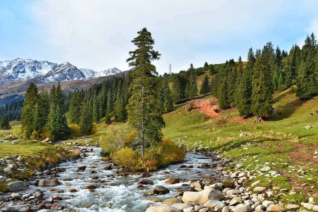
After lunch continue following the trail up Terim-Tor Valley. As you gain altitude, the valley narrows, and you will be walking next to the river.
At this point it can be a little marshy and muddy, and little rock-hopping may be required. Around this area you can find “Ishkun” an edible plant resembling celery, but with a sharp sour taste of green apples.
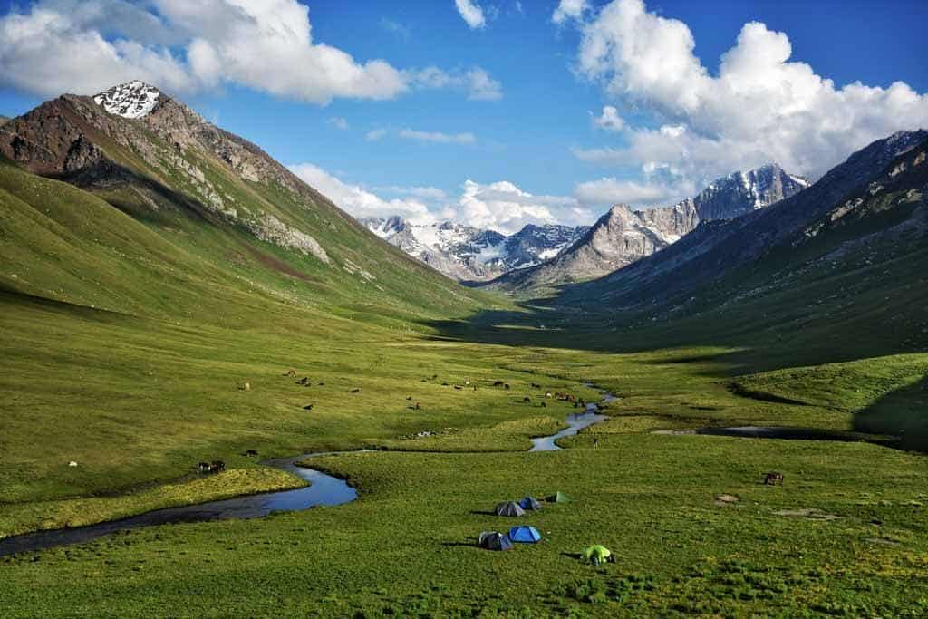
As the valley opens up keep ascending on the West side of the river. Soon you will cross a small ridge and see an ideal place to pitch your tents, usually reached around 2-2.5 hours after lunch.
This campsite is particularly scenic with the river meandering up the green valley towards snow-capped peaks.
The valley is often full of horses left there to graze. You can also see marmots, lesser whistling ducks, and a range of birds in this valley.
Be prepared, this is one of the colder campsites in the area and waking up to frost is not uncommon even in summer.
Day 2 – 13km – 8 hours
- Min Elevation: 3100m
- Max Elevation: 3521m
- Total Gain: +852m
From the campsite it is 6km walk up the valley to Bulak-Ashuu Lakes, following the West bank of the river.
From the valley floor it is not possible to see the lakes as they are perched on a rock outcropping under some sharp rocky peaks and a glacier.
You will see waterfalls coming down from these rocks, the source of this water is the lakes.
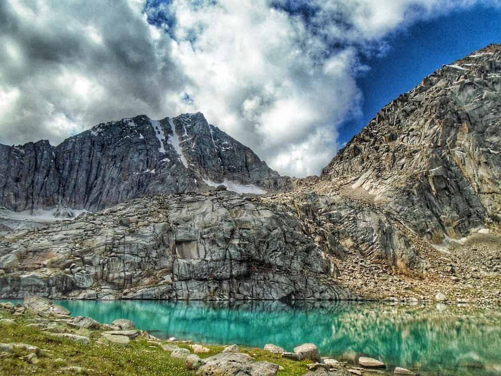
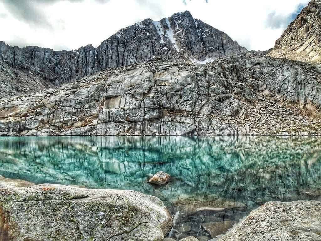
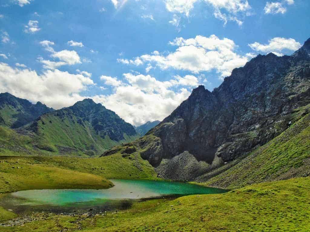
Climbing up some steep switchbacks next to the waterfall brings you to the first of the two Bulak-Ashuu Lakes at around 3500m altitude.
Both these glacial lakes have a striking blue colour from above, but as you get closer to the surface have a mirror-like quality.
Ideal for landscape photographers looking for that perfect lake reflection shot.
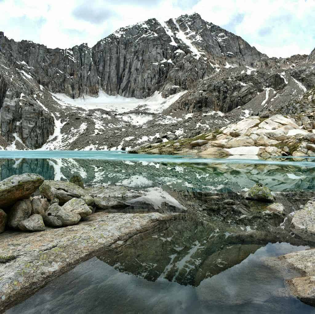
Even in peak trekking season, it is unusual for more than one group to be at the lakes on any day, so you will probably have them all to yourself.
After enjoying the lakes it’s time to head back down the way you just came up.
As you descend make sure to look up across the opposite side of the valley, where you will see another waterfall.
Also, use this vantage point to try to spot one of the many good places to ford the river.
The ground around the river can be a little boggy. A change of shoes to cross this boggy ground and the river is nice to have (Crocs or sandals work well).
Usually the river crossing presents little risk with relatively slow-moving water below knee height.
However, early season (June) or after a big storm, the crossing can be a little more challenging.
If you are worried about this, the best option is to take a pack-horse which can carry you across the river safely.
After crossing the river, it is time to tackle the high pass of the route. The route climbs West of Terim-Tor Valley, up to a height of 3521m.
This pass is still unnamed, a sign of just how new this trek is!
There are a few animal trails going up to the pass, but they regularly disappear and you will be forced to find a new animal trail to follow.
Just keep heading up following the path of least resistance and after around 1.5 hours you will reach the pass.
If the weather is clear the pass provides fantastic views of some of the bigger snow-capped peaks to the South East, and mountains forming the Kazakhstan border to the West.
Following the pass, you will descend East into Cholok-Tor Valley.
This valley doesn’t have any yurts in, so it will likely just be you and any horses left in the valley to graze.
Descend down to the river, which is the best water source in this valley and set up camp.
Day 3 – 15km – 4.5 hours
- Min Elevation: 2258m
- Max Elevation: 3100m
- Total Loss: 842m
Cholok Valley has an hourglass shape, funnelling down to a narrow gulley before opening back up into a much wider valley high above the Jyrgalan River.
From the campsite you will begin walking on animal trails down the valley on the West side of the river.
The trails closer to the river can be very wet, particularly early in the season. If this is the case, try to find a route a little higher up further from the river.
Once you reach the narrow section of the valley you will find a good trail.
This trail will take you down the valley, crossing back and forth over the river 3 times.
The first two crossings can usually be done with stepping stones. The last one requires a short easy ford of shin-deep water.
After the 3rd river crossing keep your eyes peeled for golden eagles. They nest in the rocky cliffs to the East of the trail, and they can often be seen flying around the area looking for prey.
The Cholok-Tor river you are following eventually joins the Jyrgalan River around 6km downstream from the campsite.
It is best to cross to the West side of Cholok-Tor river before it joins the Jyrgalan River.
There are a few places this can be done with stepping stones but they are not clearly marked so you need to keep a lookout for them.
If you cannot find one of these crossings it is also possible to ford the river.
Once you cross to the West side of Cholok-Tor keep following the river down to the convergence with Jyrgalan River. From this point you have good trails to follow North all the way to Eki Chat Jailoo.
Keep following these trails, with the Jyrgalan river on your right. You will see many yurts, with friendly children shouting hello.
If you are lucky you may be invited in to see the traditional yurt and have tea and drink Kumys (a traditional Kyrgyz drink made with fermented horse milk) with the family.
After around 1 hour walking from the convergence of the rivers you will come to Eki Chat Jailoo, which you viewed from the opposite side during the first day’s lunch break. Once again, this area makes a nice lunch stop.
From Eki Chat you pick up the rough jeep road from day 1. Just keep following this road north along the Jyrgalan River and you will slowly descend back to the plateau with Tulpar Tash (Horse Rock) above Jyrgalan village.
After passing Tulpar Tash lookout for the electricity pylon. As soon as you see the pylon aim straight towards it.
Next to the pylon are the steep dirt tracks taking you directly to the village.
If it has been raining a lot and these steep dirt tracks are too slippery, continue along the jeep road, that will return you to Jyrgalan along slightly longer but much flatter route.
Congratulations on completing the Bulak-Ashuu Lakes Trek, Jyrgalan’s newest trail.
Now it’s time to relax, enjoying a hot shower, a big home-cooked meal, and the comfort of a cozy guesthouse with warm beds.
BONUS – Ailampa Lake Extension
For those looking for a longer, more challenging hike, visiting Ailampa Lake is a perfect extension.
For this route, follow the standard Bulak-Ashuu Lakes route up to the end of day 2.
On day 3 instead of descending down down Cholok-Tor valley you will ford the river and cross a pass directly East of the unnamed pass you crossed on day 2.
This pass is also unnamed and has an elevation of 3581m. The pass offers beautiful panorama views along the Jyrgalan Valley.
Descend the pass and head South up the Jyrgalan Valley. You will see a sharp peak resembling a chair or throne shape.
This peak is affectionately known by local people as “Throne of the Buddha” due to this shape. Ailampa Lake is directly below the peak.
For the truly adventurous a steep hike/scramble up past the lake brings you to the foot of Ailampa Glacier and two smaller lakes.
This is a beautiful side trip, but not to be underestimated.
Ailampa Lake makes for a great camping spot, particularly for photographers looking for sunrise/sunset photos.
The lake is also a popular fishing spot for some of the local men from Jyrgalan.
To return to Jyrgalan from the lake, head North down-stream of the Jyrgalan River.
You will need to cross this river and get onto the East bank at some point.
There are a number of possible places where crossing on foot is possible, or alternatively you can find a yurt and ask for a horse ride across.
From Ailampa Lake to Jyrgalan Village is 19km, but all down-hill on good trails.
It can be done as an enjoyable day hike of around 6 hours.
For those looking for an easier last day, or trying to get back in time for the last Marshrutka to Karakol, it is recommended to not camp at the lake, but instead a little lower down Jyrgalan Valley.
This higher section of Jyrgalan valley, which is not seen on the standard Bulak-Ashuu trek, features lots of yurts and is a great place to observe traditional Kyrgyz life.
Adding in Ailampa Lake adds an extra day to the standard Bulak-Ashuu trek. Pushing the trek to 4days/3nights, with a total distance of 50km and an additional high pass.
Further Questions?
For any questions about trekking in the area, including Bulak-Ashuu Lakes, Destination Jyrgalan is the organisation to contact.
This can be done by email (destination.jyrgalan@gmail.com), or if you are already in Jyrgalan you can drop by their office inside Ala Kol Guesthouse.

4 thoughts on “The Ultimate Guide to the Bulak-Ashuu Lakes Trek in Kyrgyzstan (2026)”
A GPS-Trail would be nice (and necessary. Because there are no trails on maps.me or OSM.
The lakes are situated in this GPS spot: +42.452429, +78.994990
If you buy the hiking map „Karakol & Jyrgalan“ at the offices you‘ll see the trail on the map.
Hope this helps a little!
Thanks for that information. Definitely you can buy a map and do the hike yourself if you choose. We hired a local guide and a horse pack to carry our gear. We recommend hiring a guide (and a horse pack if you want) as you give a local/s a job and it is not that expensive. 🙂
HI, i was wondering if you have the GPS route we can follow, or a specific starting point. I cannot seem to find ‘Bulak Ashuu’ on google maps, Alltrails, Wikiloc or Maps.me and I would love to do this hike!
A reader just replied above with some GPS Routes. As they said you can buy a map or drop into Destination Jyrgalan and ask for a GPS Map. You can rent camping gear from them also if you need. If you want, you can organise a guide from the office also and they know the way and can translate for you when you meet locals. Have a great hike. 🙂